
Marin is a great place for hikers, and Mt. Tamalpias is loaded with good hikes. I expect to be here more as the rains start. The streams here and in the Marin Water District lands are beautiful and abundant.
Full Gallery
Pop Up Slideshow
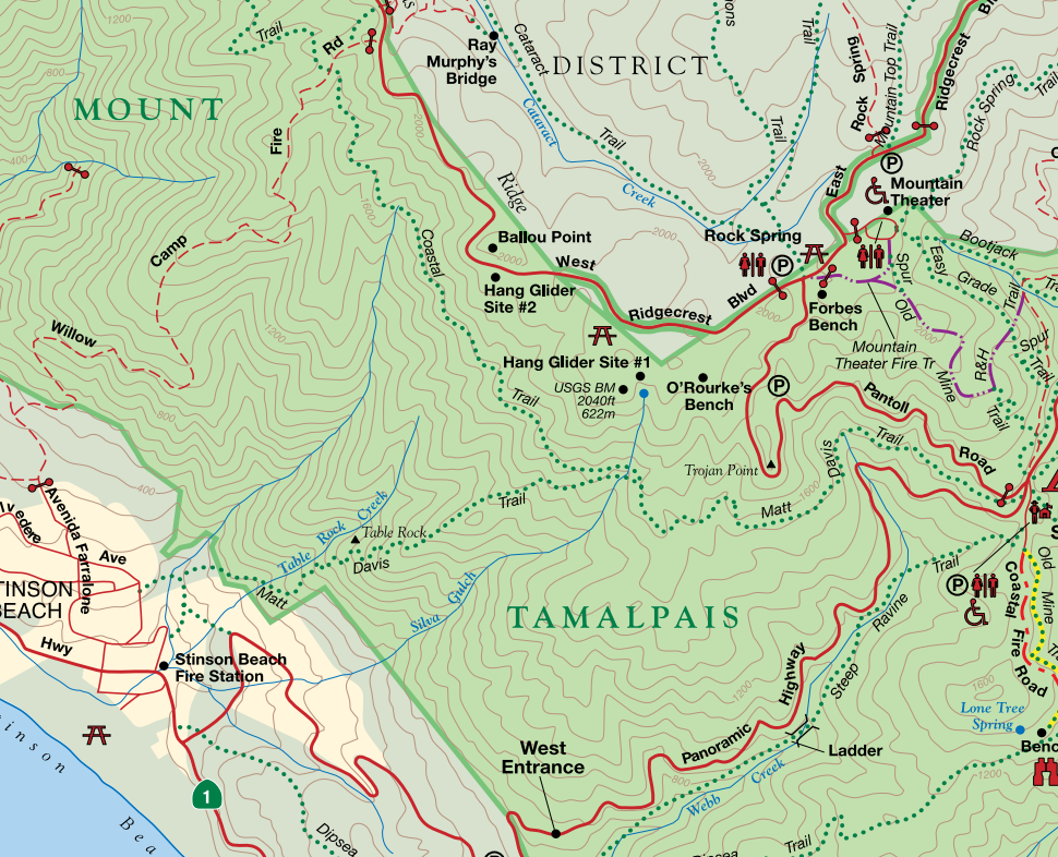
Trail Map and Brochure
Get Directions to Trailhead
Buy Prints
Friends of Mt. Tam website (Hike recommendations)
Hike:
From the Pantoll Ranger station, I took the Matt Davis Trail. The trail goes all the way to Stinson Beach, and also connects to the Coastal Trail. If you park at the ranger station lot, you'll pay a parking fee (currently $8). There is also a smaller lot above, but the gates close at sunset.
There is a sign marking the start of the Matt Davis Trail.

Starting out on the Matt Davis Trail, you'll pass a bench and traverse a hillside before you enter the canopy.

I visited this trail twice. On my first trip, the light was just terrible for photography. I still took pictures, but decided to come back and see this place in better light. I came back a week later, this time in late afternoon. In the following images, the late afternoon light better illuminates the leaves and foliage, and shows off more of the tree structure.
 The trail is well constructed, braces and bridges seem solid.
This is a beautiful trail, with a nice variety of trees and foliage. Moss and lichen are abundant, and the moss becomes especially vibrant after rains.

Keep an eye out for this Madrone reaching out to grab unwary hikers...

Notice, as you hike, the structure and variety of the trees on the hills above and below you. You can sense the community of nature as you hike through the mossy Bay trees and twisted, majestic Oaks.

 The whip will keep you moving along on your hike.
This trail will change dramatically during the rainy season. If you visit in the winter, after a few heavy rains, the hillsides will be running with little streams and feeder creeks.

 Sometimes, when I hike, I get the feeling I'm being watched...

 You'll see this guy up on the hillside.
At 1.6 miles, the trail splits as you come out of the canopy. The upper trail is the Coastal Trail, the lower one is the Matt Davis Trail.
 Upper trail leads to Bolinas-Fairfax Road. Lower trail is the Matt Davis trail to Stinson Beach.
 Hiker up on the Coastal Trail
 Hikers on the Matt Davis Trail
I took the Matt Davis trail, and my goal was to hike to a lookout spot not long after the split. When you see this trail marker, look to your left. Climbing up on to that trail will take you to the lookout spot.

You'll climb up a little hill, and then you'll see the Cypress off in the distance.
 The lookout point is past the Cypress
The curious hawks, turkey vultures and other birds might come over to check you out. Even with my wide angle landscape lens, this guy came close enough for me to take his picture. Maybe that was his intent...

As you face the ocean, look to your left. Off in the distance, beyond the hills, you can see San Francisco and the Golden Gate Bridge.

This beautiful but bruised Oak is just off the trail. Be gentle and don't climb on it.

There is a nice view as you look back to the hills and the forest. The canopy is off to the right. To return back to the trail head, follow the spur back to the Matt Davis Trail and take a right. If you want to go all the way to Stinson beach, go left.

I turned right and back in to the forest as the warm late afternoon light faded.

Even late in the fall there was a trickle of water running in this stream bed, making the surrounding foliage more lush and vibrant.

The trail looked quite different on the return direction. Watch for toothy roots that might grab your ankle and not let go, or maybe just try to trip you...

At the end of this hike, I didn't want to leave the trail. I watched the setting sun light up the moss on these trees, right off the trailhead.

The Pantoll ranger station is a bit of a drive to reach, but offers acccess to a variety of trails. The road leading there is twisty and steep, but this area is worth multiple visits.
Be safe, have fun and please leave no trace.
Slideshow:
Map of hike, elevation and total distance: