
Rocky Ridge Loop Trail
On the East Bay Mud Trail Map, the Ramage Peak Trail starts at the Chabot staging area. When you start the hike, you only see the sign for the Rocky Ridge Loop Trail.
 Trail marker by the sign in box
This is the only trail marker, but continue on here for either an out and back loop or a shorter out and back hike. I tried to find the trail marked "Trail" on the map, the one that juts out, heading east, then south. At .9 miles, there was a trail marker with an arrow continuing the route, but no sign of the trail that leads nowhere. I guess that will be a mystery.

The first part of the hike is under a nice canopy. After a normal winter, you would see some nice streams on this hike as well, but this season they were dry.
 Even though we had a somewhat dry winter, there is still a lot of vibrant growth under the canopy.
 There are mostly Oaks and Bays in this forest. You'll see a few Redwoods, but they're smallThe trail starts to open up at about .9 miles, and you'll start a fairily steep climb. I don't know if it was the weather or if I just looked like a tasty morsel, but the flies were on me during the climb. The wind and little bit of rain seemed to chase them away at times, but there were a lot of them.
 The trail opens up and you start your climb to the ridge line
 Fossils!
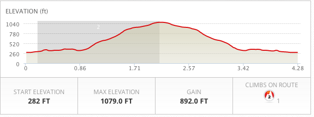
For this hike, go as long as you want, then turn around. Or, continue and do the Rocky Ridge Loop. If you do the whole loop it would be about a 12.5 mile hike, according to the map. Much of it would be on the ridge line without shade, so bring a lot of water and nourishment.
 This is a majestic tree you'll see coming and going
 Not too far from the Christmas tree far, the light was hitting the trail nicelyI suggest this hike for exercise and/or contemplation. The trail is well marked, and there is parking and a bathroom at the trailhead. You'll need a permit from EB Mud.
Enjoy and be safe!
Trail Map/Permit
Full Gallery
Prints
Slideshow:
Route and Stats:
 East Bay Trails
Reader Comments